|
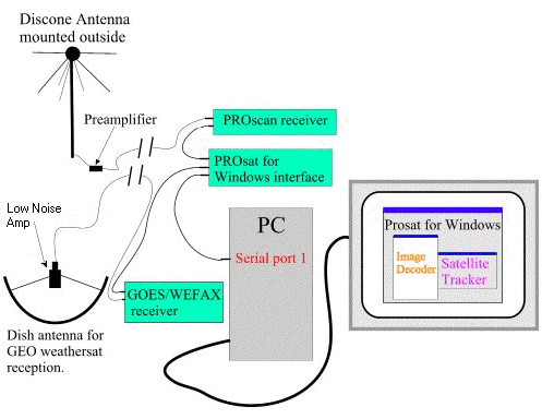
The Timestep
WEFAX receiver takes the 1691MHz input signal
and outputs an audio signal to the PROsat interface
box.
The PROsat
program can thus obtain images from both the polar
orbiters and GEO sats. The program includes various
tools for handling the GEO images and for building
animations.
Advanced
Satellite Ground Station
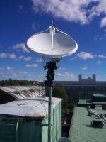
Parabolic
dish with automatic rotor control for tracking
non-geostationary satellites.
After I left
Sweden, Prof. Thomas Lindbald and Bruce Lockhart
continued to develop the ground station and went
beyond weather satellite imaging. Using a tracking
system developed by Bruce, a second dish was installed
with a motorized
rotor system that allows the dish to track
a moving satellite as it crosses the sky.
While waiting
for construction and launch of the Swedish Hugin
and Victoria nanosats, the aim is to develop the
capability to receive data transmissions from
other scientific satellites.
With such
a capability, it will be possible to develop student
projects, e.g. for senior theses, in which the
student can learn to receive and analyse actual
space science data.
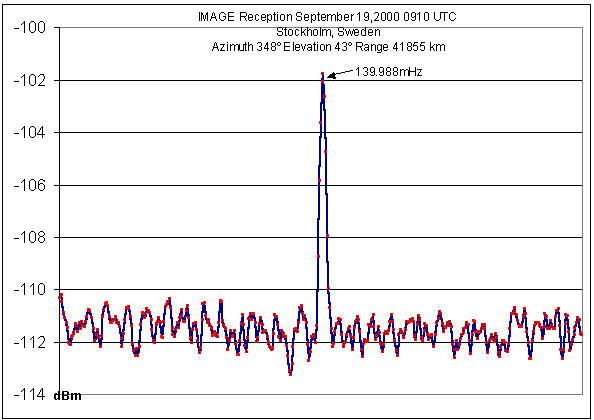
Though still
in the development stage, they have succeeded
already in obtaining signals from the IMAGE
spacecraft that is studying the earth's magnetosphere.
See graph
of signal strength.
Eventually,
transmission capabilities will be added so that
full communications with and control of the nanosats
can be accomplished.
Update:
June.8.04 - As shown by the graph,
Bruce and Thomas were able to receive a signal
from Image but unfortunately they never got beyond
this to the point of decoding data from the satellite.
It was difficult to get the assistance needed
from the Image group within the time before Bruce
retired. A program at Goddard to assist student
groups in building ground stations also never
got going.
Generally,
it is difficult to obtain the necessary technical
specs, hardware, and software needed to pickup
and decode data from scientific satellites. The
groups have other priorities than helping outsiders
look at their hard earned raw data before they
do.
Note that
some of the nanosats using the amateur bands are
student scientific satellites and you might be
able to pickup data from the instruments on these
spacecraft.
|


