SpySats, WeatherSats, LandSats, RadarSats, and
all sorts of other Sats are looking down on the earth
to see what's happening there.
The first earth observation satellites were the spy
satellites used during the Cold War to find out what
the other guys were doing. (See Spysats
in the History
section.) Weather satellites soon followed.
With the end of the cold war, the use of high resolution
imaging satellites for commercial purposes has
become a new business. Several companies have, or soon
will have, such satellites in orbit, and will sell the
images for various remote sensing applications. Satellite
remote sensing (RS) is, in fact, becoming the next
big space money maker after telecommunications.
The RS data from space might simply be photos
using visible light. Some spysats, for example, take
photographs and return the film in canisters dropped
out of orbit.
However, the imagery can also be in the infrared.
Or in many different colors, multi-spectral,
or in many, many different colors, hyper-spectral.
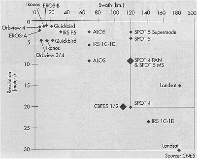
The swath, i.e. the width of the surface spanned by
the image, also varies considerably. Some applications
may need high resolution for small areas whereas other
applications, such as resource management, prefers to
see bigger areas at coarser resolutions. See the Resolution
vs Swath graph for the various remote sensing
satellites in operation.
Radar
imaging is another powerful RS technique
where a satellite transmits radar pulses and then detects
the reflections from the earth. Such radar can see through
clouds and even into dry ground. Radar imaging has been
used by archeologists, for example, to search for ancient
cities and ruins.
Each imaging approach provides a unique window on
the earth. See the remote sensing introductory
links for more information.
Collect spysat images:
Obtain images of your city and perhaps even your neighborhood.
High resolution space images are now becoming available
to the general public. The TerraServer,
for example, now offers spy satellite quality images
over the web. Demand was so great when it first went
online in the summer of 1998 that the servers at Microsoft
went bonkers. Apparently, owning a satellite image
of ones neighborhood or city seems like a fun idea
to many people. (TerraServer now reports that half
its sales are to consumers.)
Follow world weather:
Images from weather satellites around the world
are now available in near realtime on the web. Also,
fascinating new types of atmospheric imagery are becoming
available such as those of wind
patterns.
Receive satellite images
directly:
The hobbyist can assemble a receiving
station to pickup the images directly
from weather satellites with a satellite dish, and
then display and manipulate the data on a personal
computer.
Satellite Eyes
Introductions
Numerous primers, tutorials and other
introductory information on remote sensing are available
on the web:
Maps.google.com
- web browser display Google
Earth - standalone program
Select the satellite option and then enter an address
of interest in the top box. The system uses satellte
images from DigitalGlobe
(see below).
Digital
Globe
DigitalGlobe (formerly Earthwatch) will provide high-resolution,
multi-band earth images from its Quickbird satellite
that was launched in October 2001. The satellite will
provide images of even higher resolution (~.6m) than
theSpace Imaging's Ikonos satellite.
In 2013, GeoEye,
which had previously formed from Space Imaging (founded
by Lockheed-Martin) and Orbimage (founded by Orbital
Sciences), merged with DigitalGlobe.
TerraServer
This company based in Raleigh, North Carolina offers
satellite and aerial pictures of much of the earth.
They work with a large number of imagery providers.
Online search tool allows users to find images of sites
around the world.
Microsoft also offers its Windows
Live Local, a map tool with satellite plus aerial
imagery of the US.
Satellite
Imaging Corporation
This company is "a global provider of high resolution
image data, Geographic Information System (GIS) services,
and mapping solutions. SIC accesses some of the world's
most specialized remote sensors to procure satellite
imagery and aerial photography for major industries.
Sensors such as QuickBird, IKONOS and SPOT-5 produce
high resolution satellite imagery as detailed as 0.6m
from the QuickBird sensor."
TerraFly
This site at Florida International
University provides a "zoom in" service
on a given location, via address entry, using satellite
and aerial photography.
A popup applet provides various options including
a map overlay with labels on major highways and other
landmarks.
GlobeXplorer,
Inc.
This site gives consumers free access to high-resolution
aerial and satellite photos. One can enter a U.S. address
of most metropolitan areas and then zoom in on neighborhoods.
Maps pop-up to assist in navigation.
The company will make money by selling higher-quality
images on a subscription basis to other companies and
web sites.
The company claims to have the world's largest database
- 12 terabytes - of aerial and satellite imagery.
Sovinformsputnik
This Russian company now competes with Space
Imaging in offering for sale 1 meter resolution images
of just about any place on earth. Samples of the 1m imagery
include sharp views of Los
Angeles and
New York City.
ImageSat
International
This collaboration of an Israeli company and others
will market images from its constellation
of imaging sats. The first satellite - Eros-A1 was successfully
launched in Dec 2000. Gallery.
National
Virtual Data System Online Store
Buy beautiful photos and posters of the earth at this
NOAA
store that draws upon huge database of remote sensing
measurements over many years. Search by region, keyword.
Many types of images available.
Spot Image
This French company has led the way in the commercialization
of remote sensing. It was the first private company
to sell RS images on the open market.
It's satellites were low resolution compared to spy
sats, but they looked in spectral areas of particular
interest to agricultural, mining, and other applications.
AstroVision
- will launch 5 GEO satellites to "...broadcast
live, true color images of the planet 24 hours a day
- providing businesses, educators, scientists and
individuals, indeed, all the Earths inhabitants,
with a unique window on spaceship Earth." First
launch planned for 2001.
Astronaut Don Pettit during Expedition
6 to the International Space Station
offers video called "Cities at Night; an Orbital Tour
Around the World" using images
made with a special camera setup that compensates for
moving of the station during
long exposures to obtain magnificently sharp images
of the earth at night.
Astronaut
Photography
One of the earliest suggestions for human tasks in space
was to carry out earth observation for both military
and civilian applications.
The human eye provides tremendous discriminatory ability
and can detect unusual features far more quickly than
autonomous analysis systems.
However, as manned flights remained infrequent and
expensive, unmanned military spy sats and remote sensing
sats came to dominate earth observation.
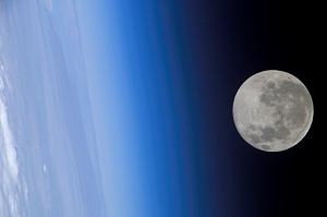
Now, though, humans are making a comeback. With astronauts
working for long periods on the ISS, which has an observation
window with exceptionally
clear glass, they are showing the power of human
observation.
Photos taken by the astronauts have reached resolutions
of 6m, in the range of the best remote sensing satellites.
Astronauts can also come upon for interesting ephemeral
events that stand out but might have been missed by
RS satellites.
If
allowed to develop, researchers on the ground could
eventually interact in real time with the astronauts
and give quick feedback on what they are doing. The
researchers, for example, might see something interesting
in a current image and then ask the astronauts to look
for similar features at another spot on the earth.
rove-to - 387,033
Shuttle images of Earth organized according to country.
Oceanography
from the Space Shuttle - This publication from
1989 is out of print. This pictorial survey of oceanic
phenomenon visible to the naked eye from space is
now only available on this web site. Thumbnails give
previews of the many beautiful images.
Twitpic.com/photos/Astro_Soichi
- Japanese astronaut Soichi
Noguchi who spent several months on the ISS in
2009-2010, took many marvelous pictures of the earth
while on the ISS. He would notified the followers
to his Twitter
account whenever he posted a new image on his
web gallery.
Earth
as Art
The images of earth from space have long been noted
for their mesmerizing beauty. NASA and the USGS recently
posted a collection of some of the most stunning earth
shots under the Earth as Art title.
NASA's
Visible Earth
A" searchable directory of images, visualizations,
and animations of the Earth." You can quickly find
images of a particular type of landscape, e.g. deserts
or rivers.
Operational
Significant Event Imagery
If you hear about a hurricane, volcanoe, large area fires,
or other large event, chances are that this site will
offer some images of the event from space.
NASA
Earth from space
This NASA database holds 250,000 images of earth. Photographic
prints can be purchased for the images in the
database.
Landsat
The series of NASA remote sensing satellites, some of
which were privatised. Many sites include Landsat imagery
along with other satellite images. Here are a set of
sites dealing specifically with Landsat imagery:
USGS
- Maps, Imagery & Publications - See the images
from the newest Landsat. This satellite is remaining
in US Government hands so the image prices will be
much lower than those from the earlier privatised
satellites.
LandsatLook
Viewer - interactive tool allows you to compare
images of a given location as seen by Landsats over
the decades.
NASA/ LandSat
- Links to imagery databases for the Landsat series
of remote sensing satellites. Includes the new Landsat
7.
NASA
Aqua
This satellite launched in May 2002 is dedicated to
the study of the earth's "water cycle, including
evaporation from the oceans, water vapor in the atmosphere,
clouds, precipitation, soil moisture, sea ice, land
ice, and snow cover on the land and ice."
NASA
Earth Observatory
This site presents images and data from NASA earth observation
spacecraft including Landsat and Terra.
The Observation Deck section allows you to build
animations showing changes on the earth as since
from space over long periods. For example, look at the
changes in Vegetation
since 1981. See also
"...allows any user to zoom from satellite altitude
into any place on Earth, leveraging high resolution
LandSat imagery and SRTM elevation data to experience
Earth in visually rich 3D, just as if they were really
there.
Particular focus was put into the ease of usability
so people of all ages can enjoy World Wind. All one
needs to control World Wind is a two button mouse.
Additional guides and features can be accessed though
a simplified menu. Navigation is automated with single
clicks of a mouse as well as the ability to type in
any location and automatically zoom into it.
World Wind was designed to run on recent PC hardware
with 3D acceleration."
It runs on a PC and "requires DirectX 9b and
the .NET Runtime environment to be installed. These
have been included in the World Wind installer."
TOMS
- Total Ozone Measurement Spectrometer
Check the levels of ozone over the earth with images from
the series of small NASA satellites especially designed
and orbited to measure atmospheric ozone.
USGS
GLIS - Global Land Information System
The U.S. Geologic Survey's Earth Resources Observation
Systems (EROS)Data
Center in Sioux Falls, South Dakota holds the world's
largest database of earth science information.
Use GLIS
to browse the database of remote sensing (aerial as
well as satellite) and spysat images. Landsat, Cororna,
radar, etc, imagery available. (Eventually to be replaced
by earthexplorer.usgs.gov)
Purchase of prints with shipping is available. PriceList
"The U.S. Geological Survey (USGS) distributes
film negatives, positives, and paper prints from declassified
satellite photographs collected by the U.S. intelligence
community during the 1960's and early 1970's. All
standard products are distributed at the cost of reproduction
plus shipping and handling. These data are archived
at the USGS' Earth Resources Observation Systems (EROS)
Data Center, in Sioux Falls, South Dakota, and are
available through the Global Land Information System
(GLIS)
search and order system." - USGS Cororna website
a rich, realistic digital simulation that
lets you explore Earth from the window of the International
Space Stationas if you were an astronaut. You can
fly over the dramatic Himalayas, the vast Sahara,
lush rain forests, or the impressive Grand Canyon.
Explore and learn more...


