We continue here with more remote sensing links and
info.
The first sections deal with receiving satellite
imagery on your own radio receiving station. You don't
have to own a ham radio license to monitor broadcasts,
just the proper receiver and antenna.
Also, many government weather and research services
now provide their data free over the internet. So you
can track hurricanes, for example, in real time.
Build a sat station
for yourself, school, or space club. Weather satellites
that you can pickup include low orbiting, low resolution
birds to geostationary, high resolution ones.
More remote sensing resources
are given plus a section providing examples of remote
sensing applications.
Satellite
Imaging at Home & School
HobbySpace
Radio
See our space radio pages for more information on receiving
data from satellites.
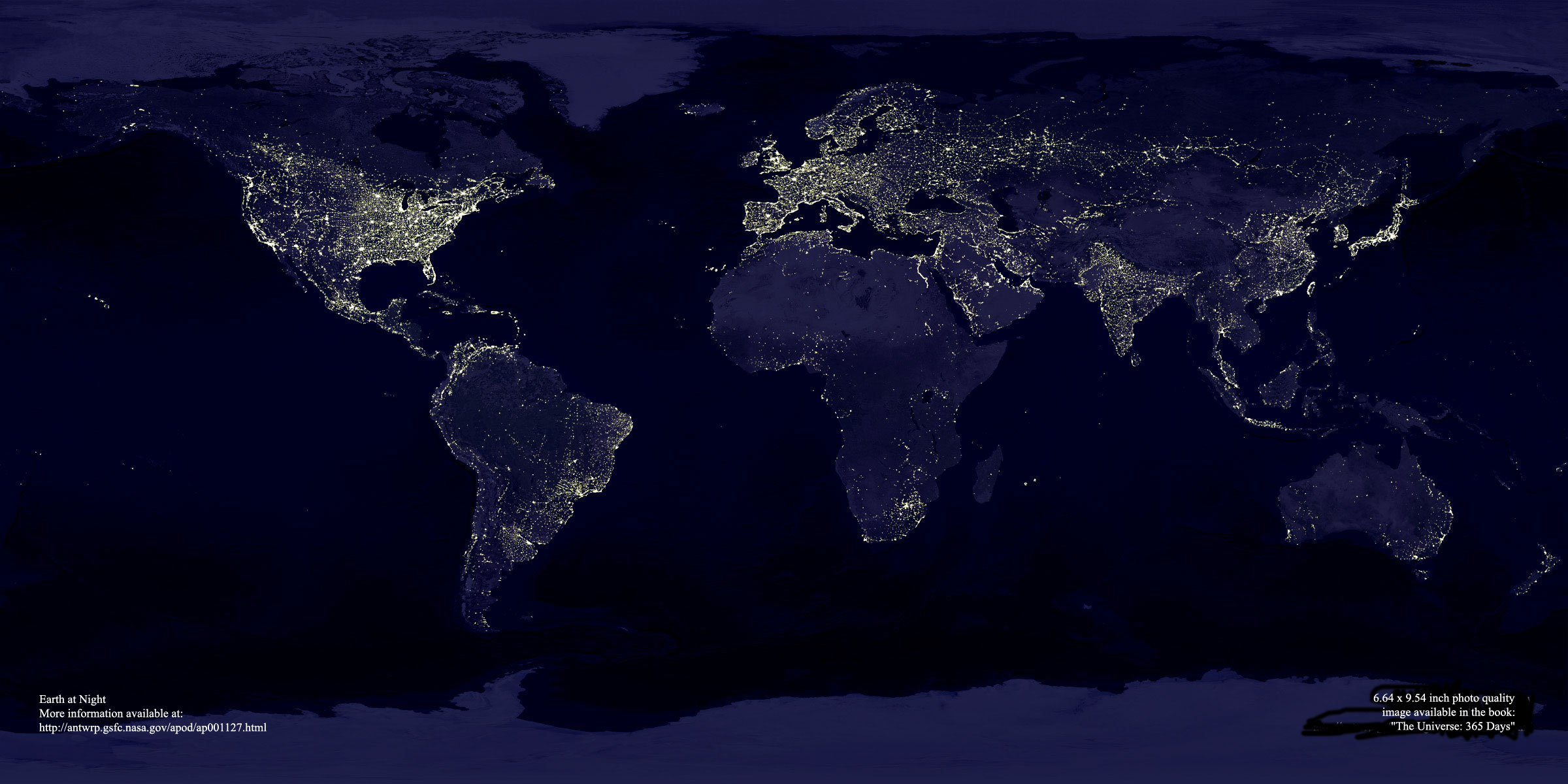
" This site provides information on obtaining
free or low cost Landsat, GOES, and Space Shuttle
images. Also included are links to free satellite
image processing software. Tip sheets will show you
how to create 3D perspective views of Landsat images
and how to colorize GOES weather satellite imagery.
"In the past, satellite imaging was the exclusive
domain of professionals working for government or
university organizations. Thanks to advances in desktop
computing and the wide spread availability of the
Internet, satellite imaging can now be enjoyed by
an enthusiast in the comfort of one's home.
"Images from earth resource satellites, weather
satellites, and the Space Shuttle in a variety of
resolutions are all easy to obtain via the Internet.
This site will show you where to obtain such imagery,
and teach you a few techniques for image processing
satellite images." - Mike Brown's Satellite Imagery
website.
MultiFAX
Capture weather satellite images in real-time with your
satellite receiver and PC. Can obtain images form
NOAA, GOES, and Meteosat weather satellites.
Two MultiFAX demodulators are available for an expansion
slot or externally via the parallel port. Extensive
software package includes satellite tracking, image
capture, image enhancements, etc. MultiFAX also sells
a receiver.
"...caters for everyone interested in remote
imaging from satellites. The group which has a membership
of nearly 2,500 spread across 45 countries, is keen
to assist new members and provide an ongoing service
to our existing membership, which includes both professional
and amateur interests..."
Beginners section provides lots of info on setting
up your own receiving station. Also, info on equipment.
Monitoring
Times - Unfortunately, the wonderful magazine
Satellite Times, which specialized in information
for the space radio enthusiast, is no longer in print.
However, many of the same types of articles, news,
and ads have been folded into the Monitoring Times,
a sister publication of Grove
Enterprises Inc.
NRL - Monterey
The Navel Research Laboratory's meteorological division
in Monterey, California provides this site with lots
of weather and remote sensing information. Check out
, for example, the
It also provides a lot of nice background info such
as this section on space
based weather resources and on satellites.
METEOSAT
at Univ. Nottingham
This group at the University of Nottingham presents
the latest images downloaded from the European METEOSAT
Weather Satellite
SeaWifs
Biosphere Globes
See the latest multi-spectral images of the earths oceans
taken by the SeaWiFS
imager on Orbview 2).
The European Envisat
spacecraft provides a range of remote sensing services
including measurements of water levels around the world.
See also the Envisat
Live gallery for other near real-time environmental
imagery.
Hurricane
Tracking Software - Tracking The Eye
This shareware program from HurricaneSoftware.com
allows you to track hurricanes in real time using data
and satellite imagery downloaded from weather databases
on the web. Lots of options, graphics and animation features.
EarthKam
This NASA funded project provides students with control
of a camera on the shuttle in orbit. The goal is to
integrate satellite imaging into the teaching of Earth
Science. Headed by Sally Ride.
Mississippi
Space Commerce Initiative
A collaboration of NASA Stennis Center and several companies
and universities to develop remote sensing technology
and applications. Several useful pages including links
to RS companies.
"...dedicated to making remote sensing algorithms,
code, and technology available to all interested parties.
Resources are provided to facilitate communication
and development of open source tools. It is hoped
that this effort will attract participation from companies,
students, professors, and agencies that are involved
in remote sensing efforts."
Sea and Sky
Very beautiful and elaborate site dedicated to the exploration
of the oceans and of space. SeaSky
SeaSpace
A company that provides software to do processing of remote
sensing images to develop their full information potential.
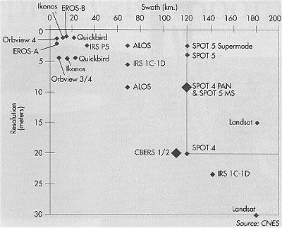
Spot Image
The first private commercial remote sensing satellite
company. It provides primarily images from the French
SPOT satellites.
Surrey
Satellite - Remote Sensing SSTL is a spinoff
company from the Univ. of Surrey group that has been
a leader in the development of small satellites. Here
the company shows photos from their low-cost imaging
satellite.
Tromsø Satellite Station This site from Northern Norway provides images
from RadarSat and other remote sensing satellites.
Forest Fire Monitoring
Satellite observations now help to monitor and contain
forest fires
Goddard - Remote
Sensing Tutorial - Goddard Center provides this
very extensive educational resource on the history,
techniques and applications of remote sensing. Includes
PDF file versions.
NASA
Earth Observing System (EOS) Education Project
- "develops interdisciplinary programs, and deploys
advanced technologies to the global K-16 education
community. We investigate how geo-technologies help
enhance our exploration and understanding of the diverse
and changing landscapes of our world."
NASA: Destination
Earth - Large educational site dedicated to the
theme of studying the earth as a total system: weather,
oceans, solar input, etc. Space offers the best vantage
point to study the earth and many different kinds
of satellite observers will be launch in the next
few years as part of NASA's Earth Science Enterprise.
WW2010
- Weather World 2010 is a project at the Univ. of
Illinois to combine weather data and multimedia for
science education. Online guides include: Remote
Sensing * Meterology
Satellite Radar
imaging has become an increasingly important remote
sensing tool. While the resolution is not as fine as
for visible light images, radar can penetrate clouds
and works at night as well as it does in the sunlight.
NASA/JPL
Imaging Radar
Satellite Radar imaging has become an increasingly important
remote sensing tool. While the resolution is not as
fine as for visible light images, radar can penetrate
clouds and works at night as well as it does in the
sunlight. See the Using
RADAR Data - Science and Applications page for information
on this exciting RS technique.
RADARSAT
- CSA
The RADARSAT-1 satellite is owned and operated by the
Canadian Space Agency and it license the distribution
of its images to a private commercial company. However,
NASA launched the satellite and works closely with the
CSA in the analysis of the imagary.
GIS is a relatively new field that combines
the many types of remote sensing data with the many
types of conventional ground based information into
one big multi-dimensional database. One can then create
plots and maps illustrating interesting and often unexpected
correlations among the various parameters.
For example, one could use such a database
to relate housing density (obtained from a satellite
image) versus median salary levels (obtained from census
data.) Or versus toxic release sites (from environmental
agencies).
Such analysis is becoming a very popular
tool for many applications ranging from demographics
to city planning to placement of cellular phone towers
to environmental monitoring.
Resources
ESRI - This GIS
company provides an interesting site with many demos
of GIS techniques. See their DEMOS
page and make maps according to demographic, environmental,
and other types of parameters.
ArcGIS
Explorer - Download this program to make free
maps of your home town. Maps are not just of roads.
You can also map environmental, flood,census,
and other data
Earthsat
does processing of imagery from a variety
of satellite sources. They offer "value-added"
products such as crop forecasting, geologic analysis,
and other remote sensing services.
GeoComm -
News, links, articles about GIS, remote sensing, etc.
SpatialNews
Geography
Network - Geographic resources site that includes
interactive maps that use satellite data.
While these are not hobbies,
they provide interesting illustrations of the capabilities
of satellite remote sensing.
Animal
Tracking
Animal researchers and environmentalists
have always needed to track creatures in the wild to investigate
their behaviour and range of activities. While hiking
boots and binoculars are still required tools, so now
are satellites when it comes to tracking animals over
long remote distances and over long periods.
Lost cities, roads, and other ancient constructions
that were invisible from the ground have been found
to "stand out" when seen from the perspective
of space. Furthermore, sensors such as radar can penetrate
jungle foilage or sand and also scan large areas very
effectively.
Satellite
Remote Sensing and Archaeology
Martin J. F. Fowler offers this very nice site with lots
of information and links about using RS for archeology.
Resources
section (links to software and other tools) and a discussion
area included.
The applications of remote sensing in law enforcement,
forensic, and other legal areas are growing. These can
range from spotting ships at sea illegally fishing or
dumping pollutants to settling real estate disputes.
Visual
Forensics
This company uses d satellite terrain data to create a
computer simulations for courtroom use. For example, they
provided simulations to support the pilot in the case
of the US Marine plane that accidentally cut the cables
to a gondola in Italy, resulting in the deaths of 20 people.
Farmers can now combine remote sensing data,
e.g. images that indicate the water content of the soil
and plants, and GPS positioning information (also from
satellites, of course) to tailor their plowing, fertilizing,
planting, irrigation, pest control, etc. down to the square
meter.
Taking
Aim
The Precision Agriculture Center at the University of
Minnesota describes the techniques of precision farming.
Precision Farming combines GPS and remote sensing data
to tailor planting, irrigation, fertilization, etc. to
particular areas within individual fields.
It might seem seem strange
to go to space to predict earthquakes but, in fact, satelllite
sensing may provide vital clues to detecting precursors
to seismic activity. Radar and GPS systems can since movements
of the earth to centimeter accuracy and thus signal slight
shifts of tectonic plates that may occur before quakes.
There are indications that low frequency electromagnetic
radiation may be emitted from ground structures under
stresses that precede a quake. Satellites may have already
detected such radiation and new
projects are underway to test the theories.

